River levels fall with moderate flooding at Tumbulgum
Tuesday, December 15, 1.55pm
The Tweed River is beginning to fall after it reached its peak earlier this morning, with moderate flooding at Tumbulgum and minor flooding at Chinderah and Murwillumbah.
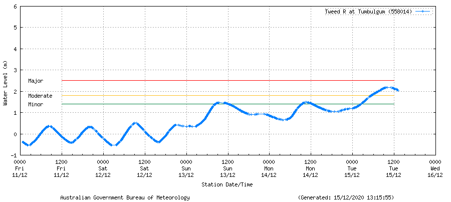
According to the Bureau of Meteorology, the Tweed River at Tumbulgum peaked at 2.2 metres around 10am this morning. The river at Tumbulgum has now begun to fall and is currently at 2.0 metres and steady.
Earlier this morning, around 8am, the Tweed River at Chinderah (Barneys Point) peaked at 1.60 metres around 8am Tuesday, with minor flooding. The current level is 1.33m and steady.
Murwillumbah peaked near 3.8 metres around 8am this morning, with minor flooding. The current river height is 2.66m and steady.
A Severe Weather Warning remains current for the region for heavy rainfall, abnormally high tides and damaging surf. Rainfall is forecast to ease today.
An evacuation order for Condong, Tumbulgum and surrounding areas remains in place.
To view the latest river heights visit: http://www.bom.gov.au/cgi-bin/wrap_fwo.pl?IDN60140.html
Condong, Tumbulgum residents ordered to evacuate
Tuesday, December 15, 11.15am
The NSW State Emergency Service (SES) has issued an evacuation order for residents within Condong, Tumbulgum and surrounding areas to evacuate via Tweed Valley Way to Murwillumbah.
Rising floodwaters have closed local roads including Riverside Drive and Tweed Valley Way north of Tumbulgum and flood levels are expected to peak around 1pm this afternoon.
The SES said affected areas are properties on Tweed Valley Way north of Murwillumbah, Condong and Tumbulgum, and low-lying areas of Tygalgah and surrounds.
An evacuation centre has been set up at Wollumbin High School, 94 North Arm Road Murwillumbah.
Residents with low lying properties are being asked to;
- Lift possessions and important items above the predicted flood height.
- Take pets, essential items, warm clothes, medicines, insurance documents and valuables with you.
- Leave as early as possible to avoid restricted roads.
- Share this information with family, friends and neighbours and help others where possible.
For more information, including river heights and the latest road closures visit Tweed Shire Council’s emergency dashboard https://emergency.tweed.nsw.gov.au/
For emergency help in floods and storms, call the NSW State Emergency Service on 132 500. In life threatening situations call triple zero (000) immediately.
Tumbulgum and South Murwillumbah residents prepare to evacuate
Tuesday, December 15, 8.30am
Residents in South Murwillumbah, Tumbulgum and surrounding areas are being told to prepare to evacuate, as further river rises are expected later this morning with the incoming high tide.
An evacuation order has not been issued by the NSW State Emergency Service (SES) at this stage but residents are being urged to prepare to leave.
The SES has issued a warning for moderate flooding in South Murwillumbah. Moderate to major flooding is predicted in Tumbulgum around midday and minor flooding is predicted at Chinderah.
According to the Bureau of Meteorology, the Tweed River at Murwillumbah is expected to peak near 4.00 metres around 10am this morning, with moderate flooding predicted.
The Tweed River at Tumbulgum is expected to peak near 2.30 metres around 1pm today, just below the major flood level.
The Tweed River at Chinderah (Barneys Point) is expected to peak near 1.60 metres around 11am Tuesday, with minor flooding.
The SES is advising residents in low lying areas of the following locations that they may need to evacuate due to rising floodwater;
- Low lying areas of South Murwillumbah residential and industrial estates
- Greenhills Caravan Park
- Residential and business areas bounded by the Tweed River, the railway line, Alma Street and the southern end of Wardrop Street and Railway Street
- Tweed Valley Way between Mistral Road and Rose Lane
- Tumbulgum and surrounding areas
The SES says this flood may be similar to the 2017 and 1978 floods.
At Murwillumbah:
- Tweed Valley Way may close between Murwillumbah and Tumbulgum, preventing road access to the Gold Coast.
- Roads in Tumbulgum may close isolating Tumbulgum.
- Tweed Valley Way may close between Murwillumbah and Condong isolating Condong.
- The flooding street can experience flooding through back up of storm water Knox Park, Nullum Street, King Street, Condong Street and Hartigan Street.
- Flood water starts to inundate Greenhills Caravan Park.
- Flood water starts to Inundate properties in Mooball Street Murwillumbah.
At Tumbulgum:
- Dulguigan Road is cut opposite the Tumbulgum village.
- Water crosses Riverside Drive immediately east of the bridge and backs up into the lower areas on the eastern side of the village.
- Tweed Valley Way to the north at “Mohomad’s” corner in the vicinity of Stotts Island and to the south at Dinseys Creek is cut.
- Terranora Road in North Tumbulgum is cut.
- Water begins to flow from the area near the boat ramp and crosses Riverside Drive into the village.
- Tweed Valley Way closed to north and south bound traffic between Tumbulgum and Tweed Heads and Tumbulgum and Murwillumbah.
At Chinderah:
- Flood water may close Fingal Road near the corner of Wommin Lake Crescent, isolating Fingal Head.
- Possible inundation of low lying areas and roads in and around Chinderah including the Tweed and Heritage Caravan Parks, Chinderah Road, River Street and Wommin Bay Drive.
- Possible inundation of low lying properties in Fingal Head.
- With Increased rain Wommin Lake can contribute to flooding on Fingal Road.
- Chinderah Bay Road may close at Jenner’s Corner (North Lane only).
- Inundation starts in Tweed Caravan Park and at the entrance of Tweed Heritage Caravan Park.
- Piggabeen Road may close at Cobaki Creek isolating properties in Cobaki and Piggabeen.
- Flood water may go over Kirkwood Road (west) and Kennedy Drive may close at intersection of Rose Street near the Pyramid Caravan Park.
- Tweed Valley Way may close north and south of Tumbulgum.
- Most properties in Chinderah are likely to be inundated some with over floor flooding.
- Flood waters may start to inundate low lying areas of Kingscliff.
- Flood water starts to inundate low lying properties in the Chinderah area including Caravan Parks.
For more emergency information, road closures, river heights, rainfall observations and forecasts visit Tweed Shire Council’s emergency dashboard: https://emergency.tweed.nsw.gov.au/
